February 2026
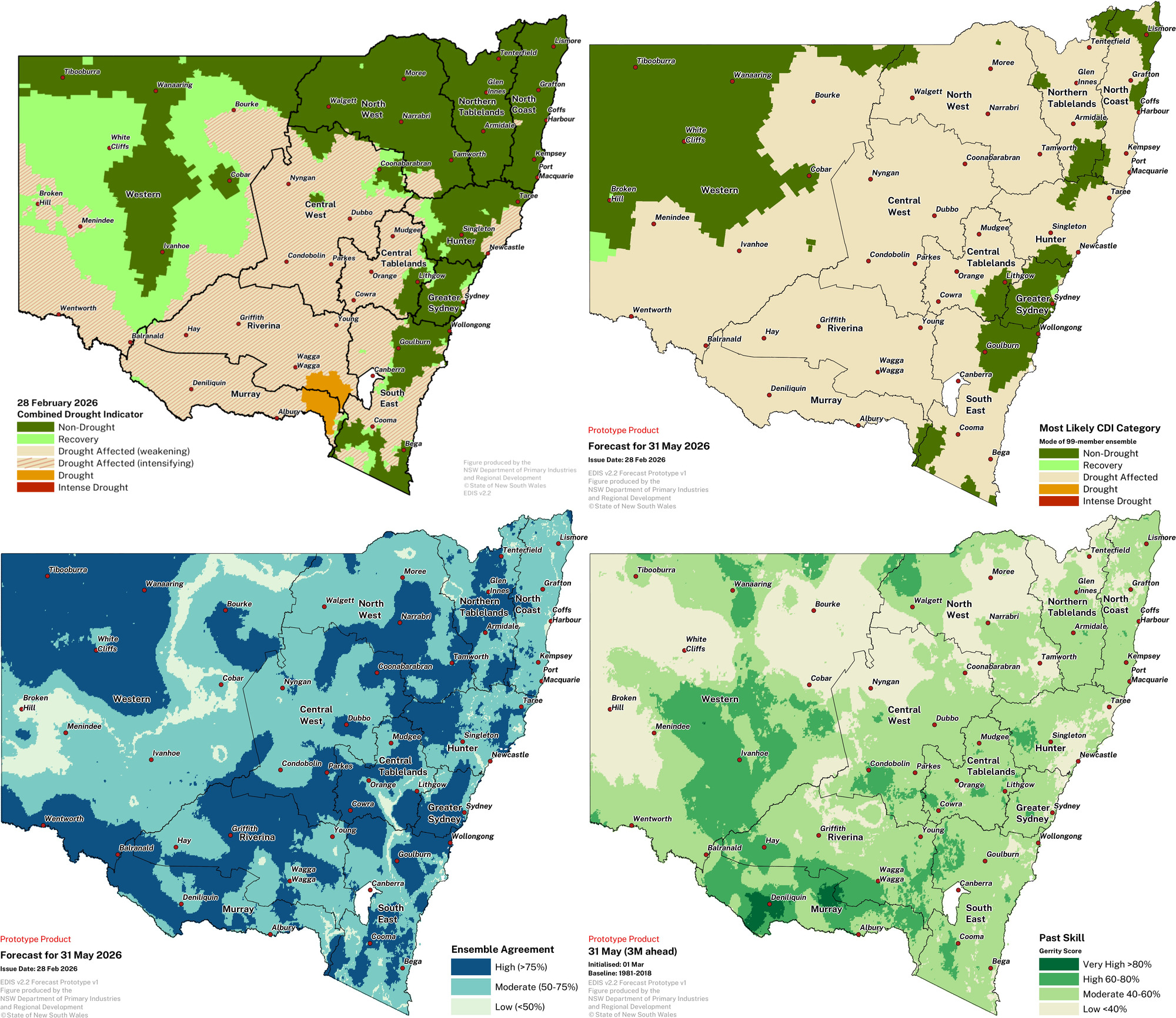
DPIRD drought forecast (for 31 May 2026)
(Issued 28 February 2026)
DPIRD’s Drought Forecast (top right) shows the most likely outcome at 31 May 2026.
- Drought conditions will likely continue in the Riverina and Murray, but ease in the east and transition to the less severe Drought Affected category.
- For the Hunter, South East, North West and Northern Tablelands regions, the most likely outcome is for drought conditions to expand.
- Conditions will likely decline further in the North Coast region and transition to the Drought Affected category.
- Conditions will likely also ease for parts of the far west and northwest of the state, and transition back into the Non-Drought category.
- The likely continuation and expansion of the CDI Drought Affected category is being driven by a mix of conditions. Including continued long term soil moisture deficits, ineffective climate conditions for production and continued meteorological drought, along with the increased chance of below median rainfall for this drought forecast period.
Forecast ensemble agreement and historical accuracy vary by region.
- In this forecast period regions of moderate to low agreement and accuracy correspond to those areas that are forecast to transition into the NSW-CDI Drought Affected category.
- Past skill for this forecast period is highly variable, and generally low to high for most of NSW.
DPIRD’s drought forecast uses the Bureau of Meteorology seasonal climate model ensemble to determine the NSW-CDI for the coming forecast period. The drought forecast figure shows the most frequent (mode) drought category in the 99-member model ensemble at the end of the forecast period.
It is important to check forecasts and observations regularly for updates over the coming season.
Forecast releases
Drought Forecast maps are provided twice a month (on the release of the SSU and around the 20th of the month). Check here to see the latest version available. The latest version could be different to the figure below.
Understanding the DPIRD drought forecast figures
Most Likely CDI Category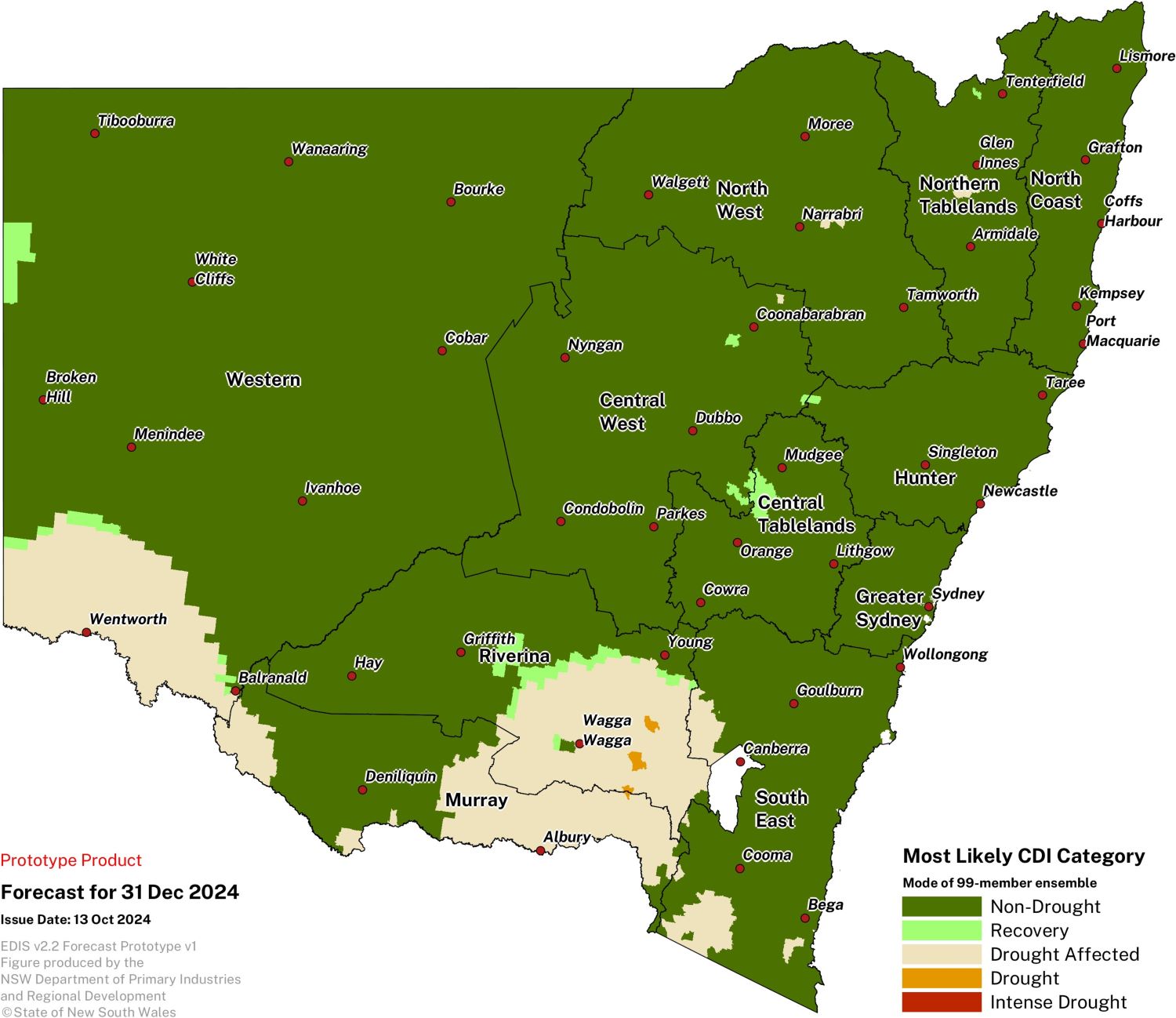
The DPIRD drought forecast for NSW presents the ‘Most Likely’ Combined Drought Indicator (CDI) category for the forecast period. The Most Likely CDI category is determined by identifying the 'mode' of the CDI. The mode is the category that appears most frequently across all possible forecast outcomes in the ensemble run. It is the most common prediction for drought conditions in the forecast period based on the model's simulations.
This map can be used alongside the most current CDI map to observe current conditions and the most likely conditions in three months’ time.
Ensemble Agreement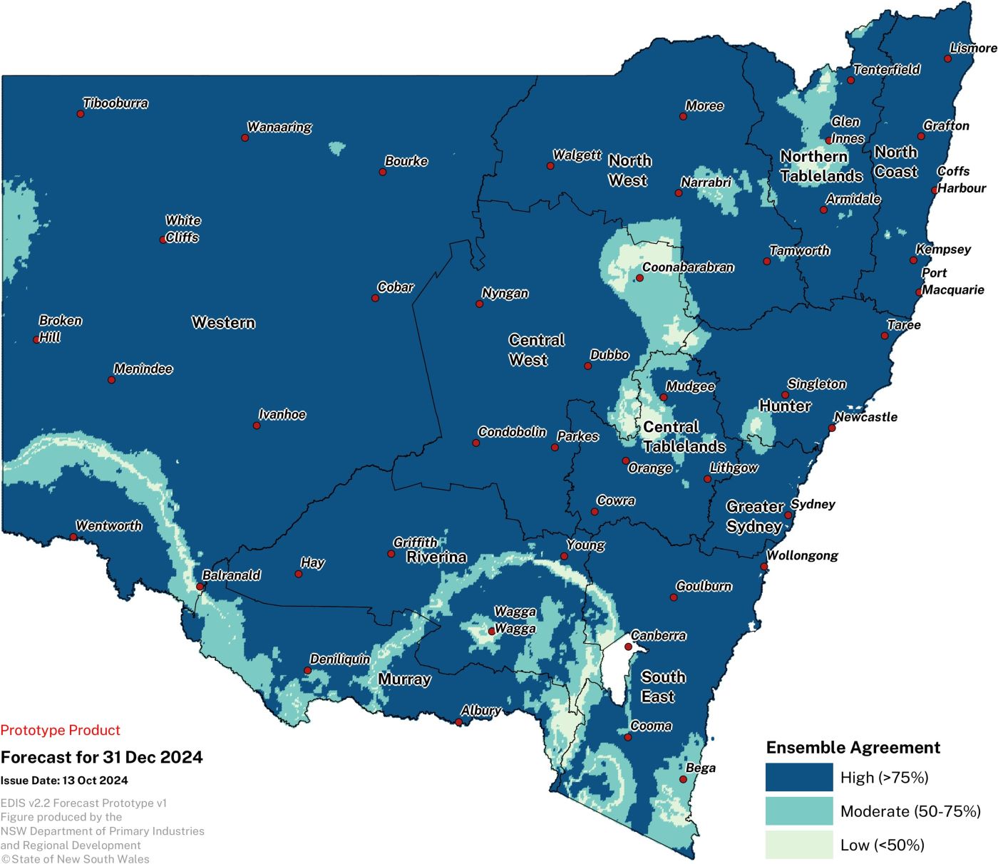
Ensemble agreement refers to the level of consensus on the mode among the ensemble members. When there is high agreement, it means that most of models are predicting a similar CDI category, suggesting greater confidence in the forecast. If the agreement is low, it suggests that there is a wide range of possible outcomes, leading to greater uncertainty in the forecast.
Past Skill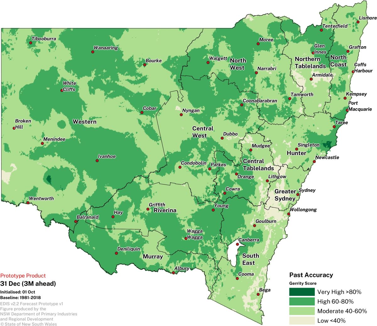
Past skill refers to how well the model predicts the correct CDI drought category compared to random climatological chance for every forecast month in the historical record (1981 –2018), allowing an assessment of the reliability of the current forecast. If the model has consistently provided skilful predictions, there is more confidence in its current output. However, if past skill is low, it might suggest a need for more caution in interpreting the forecast, especially when ensemble agreement is low.
Overview of the DPIRD drought forecast
The seasonal drought forecast have been developed as a drought early warning system to prepare for drought events, mitigate drought impacts, and better aid farm and Government management decisions.
The DPIRD drought forecast has been generated by forcing the NSW DPI Enhanced Drought Information System (EDIS) with calibrated forecast variables from the Bureau’s seasonal prediction system, ACCESS-S to produce an ensemble of drought indicators. A 99-member lagged ensemble is used to determine the drought forecast.
A technical description of the DPIRD drought forecast, including a full analysis of the systems skill, is being prepared for public release.
Find out more information about the drought forecast here.
Provide feedback
To provide feedback on the DPIRD Drought forecast, please email seasonal.conditions@dpird.nsw.gov.au
If you want to join our advanced forecast user group and help shape new products register your interest here.
To complete our feedback survey, please click here.